Oxford Scientists Create World’s Most Detailed River Map to Combat Flood Risk
Oxford researchers have developed a groundbreaking global river map that could transform how the world prepares for and responds to flooding in the face of climate change.

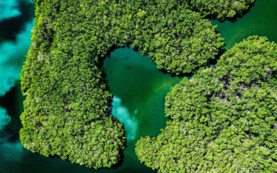
A team of researchers from the University of Oxford have unveiled the most complete map of the world’s rivers to date, offering a powerful new tool in the fight against rising flood risks driven by climate change. Known as GRIT (Global River Topology), the map captures river systems in far greater detail than ever before, showing not just where rivers flow, but how they split, branch, and interact with the surrounding landscape.
Flooding is the most widespread natural disaster globally, causing over $100 billion in damages each year and affecting millions of people. As climate change increases the frequency and intensity of extreme rainfall, especially in densely populated areas, the need for better flood prediction tools has never been greater.
Until now, river maps have often overlooked complex features such as the splitting of channels, missing the complexity of multi-channel systems and large canals. Built using high-resolution satellite images and advanced elevation data, GRIT maps 19.6 million kilometres of rivers and identifies 67,000 bifurcations (the splitting into channels), providing critical insights into how water moves across the Earth’s surface.
“It’s not enough to assume rivers just go downhill in a straight line—especially not when we’re trying to predict floods, understand ecosystems, or plan for climate impacts. This map shows the world’s rivers in their full complexity.” said Dr Michel Wortmann, who developed GRIT at Oxford as a Research Associate on the EvoFLOOD project.
GRIT can be regularly updated with the latest satellite and topographic data, making it a living tool for scientists, governments, and planners.
The work was funded by the UK’s Natural Environment Research Council through the £3.7 million EvoFLOOD programme, and will support everything from flood forecasting and drought monitoring to water quality management and conservation planning.
Read the press release here
Read the full study here